Science News
Extremes in 2012
December 6, 2012

At the AGU meeting this week, several sessions were devoted to extreme weather events. Here's a quick summary of three of these from the past year.
Superstorm Sandy
Two researchers described the effects of Sandy and similar storms on the coastal communities on the East Coast. Hilary Stockton of the US Geological Society used images to show how vulnerable some coastal spots were to the storm and how Sandy makes the areas even more vulnerable to future, smaller storms.
Dylan McNamara of the University of North Carolina discussed economic impacts of storms like Sandy on these communities, especially given the subsidizing of shoring up the coasts. If government subsidies were removed, even partially, he shows that many of these areas would see property values fall and residents simply abandoning seaside towns.
Early Snowmelt
Moving west to the Rockies, two scientists discussed this year's dry winter in the region—the driest since 1973. The early snowmelt this year (six weeks earlier than normal) threw the entire alpine tundra ecosystem out of whack, says Heidi Steltzer, a biologist in Colorado. Plants use snowmelt as a growth cue, but because it was so early this year, the plants used length of day and temperature instead. They grew 20-45 days after the snowmelt, missing the water and nutrients the melting snow provides. In addition, the plants went dormant earlier. Steltzer believes the stress made the plants race through events, going dormant and protecting themselves for a better growing season next year; although weather predictions don't look good for 2013.
David Inouye described how timing and plant growth affect pollinators, insects and birds that feed on the nectar of plants, and even small mammals that rely on the seeds of these plants. He's finding that some wildflower populations are declining in the area.
Atmospheric River
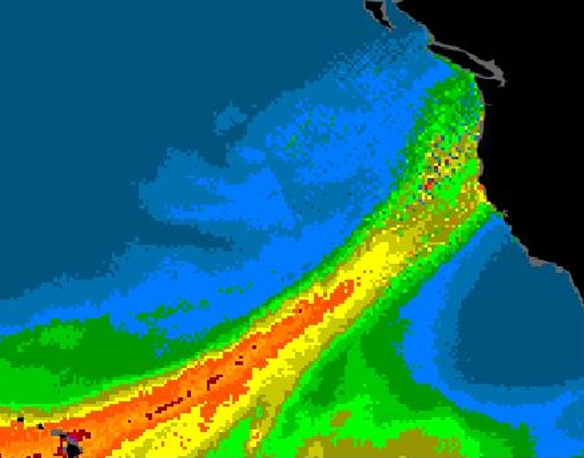
Coming all the way west to the Bay Area, a group of scientists described how last weekend's storm was due to an "atmospheric river." Atmospheric rivers are weather systems that gather and carry large amounts of water over the ocean at about 5,000-10,000 feet above sea level. NOAA, the California Department of Water Resources and the National Weather Service are building a statewide observation system to monitor these phenomena. The first Atmospheric River Observatory is being installed in Bodega Bay and should be completed within the next month. Look for a Science in Action video shortly thereafter about the new instrument and monitoring network.
Want more info on extreme events on our planet? Join our Earth Update crew in the Morrison Planetarium tonight at Nightlife at 6:30pm.