Please note: Osher Rainforest will be closed for maintenance Jan. 14–16.
Science News
Megalopolis Explosion
October 4, 2012
by Zuberoa Marcos

(Scroll down for Spanish versión)
While cities can reduce the impact an individual has on the environment by increasing the density and efficiency of human settlement, the cities themselves pave over nature. By 2030, hundreds of millions more people will live in cities around the world creating vast megalopolises and blotting out ecosystems.
According to a study published in the Proceedings of the National Academy of Sciences, the area covered by cities may sprawl out over an additional 1.2 million square kilometers by 2030. That means the area covered by cities may triple.
The United Nations (UN) predicts that cities will absorb all of the world's population growth — of around 2.3 billion people — in the next four decades.
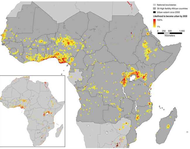
Geographer Karen Seto and her team from Yale University, authors of the study, used NASA satellite images and population and economic growth forecasts from the UN and the Intergovernmental Panel on Climate Change (IPCC) to build a map that assigned a probability of urbanization to 25-square-kilometer blocks all over the world. The team found that wide-ranging urbanization will take place in eastern China and tropical Africa.
Much of the expansion will occur near cities that are already gigantic, but some biodiversity hotspots are in danger of being swallowed by the concrete. For example, the urbanization of the tropical Guinean forests of West Africa may devour 6.8% of the regions' hotspot. The Western Ghats region of India, the highland forests of eastern Africa, and the ecosystem of Sri Lanka are other hotspots that are likely to lose ground.
Seto told Nature News the map could be used to guide conservation policies helping policy-makers shape the next generation of urban infrastructure while protecting biodiversity rich areas.
Other experts, such as Gerhard Heilig, chief of the United Nations' Estimates in Population Division, told Nature that the map itself is important because it may be the first global-scale attempt to predict the environmental impact of urbanization. But, it is incomplete. It does not consider how those future cities will be constructed, the spatial arrangement of housing, infrastructure and green space, all factors that affect the environmental footprint of an urban area.
Zuberoa Marcos is a former biologist and current science writer based in Barcelona. She writes articles regularly for Science Today.
Explosión de megalópolis
Por Zuberoa Marcos
Las ciudades, al ser lugares de asentamiento humano muy densos, pueden reducir el impacto que un individuo tiene sobre el medioambiente. Pero, al mismo tiempo, las urbes son una amenaza para la naturaleza. En 2030, cientos de millones de personas más vivirán en megalópolis que acabarán con algunos de los ecosistemas actuales.
Según un estudio publicado en Proceedings of the National Academy of Sciences, el área cubierta por las ciudades va a aumentar en 1,2 millones de kilómetros cuadrados de aquí al 2030. Esto significa que el área ocupada por las urbes puede llegar a triplicarse en las próximas décadas.
Las Naciones Unidas (ONU) predicen que las ciudades absorberán todo el crecimiento de la población mundial - alrededor de 2,3 millones de personas – previsto en las próximas cuatro décadas.
La geógrafa Karen Seto y su equipo de la Universidad de Yale, autores del estudio, emplearon imágenes de satélite de la NASA y las previsiones de crecimiento económico y de la población de las ONU y del Grupo Intergubernamental de Expertos sobre el Cambio Climático para construir un mapa que asigna una probabilidad de urbanización a parcelas de 25 kilómetros cuadrados que abarcan todo el mundo. Al analizar el mapa, el equipo encontró que el proceso de urbanización se llevará a cabo, sobre todo, en el este de China y en el África tropical.
Gran parte de la expansión se producirá cerca de grandes ciudades que ya existen pero algunas áreas ricas en biodiversidad corren peligro de ser engullidas por el hormigón. Es el caso de los bosques tropicales de Guinea, en el África occidental, que podrían ver mermada su extensión en un 6.8% por la urbanización. La región de Ghats en la India, los bosques de las tierras altas del este de África y Sri Lanka son otros lugares propensos a perder ecosistemas naturales.
Seto explicó a Nature News que el mapa podría ser utilizado para fijar políticas de conservación, para ayudar a los responsables políticos a dar forma a la próxima generación de infraestructuras urbanas protegiendo al mismo tiempo regiones ricas en biodiversidad.
Otros expertos, como Gerhard Heilig, jefe de Estimaciones de la División Población de las Naciones Unidas, afirmaron a Nature que el mapa es importante porque se trata del primer intento a escala global de predecir el impacto ambiental de la urbanización, pero que es incompleto. No tiene en cuenta cómo se construirán esas ciudades del futuro, la disposición espacial de las viviendas, de las infraestructuras y de los espacio verdes, factores que también afectan a la huella ecológica de un área urbana.
Zuberoa Marcos es bióloga molecular y actualmente trabaja como productora de TV y periodista científica. Escribe de forma regular para Science Today.
Image: Seto et al./PNAS